Two Days From Shore
In Europe, you are almost never more than two days from land. When distance is translated into time, insurance limits stop looking abstract and start mapping directly onto lived risk—fatigue, darkness, and exposure at sea.

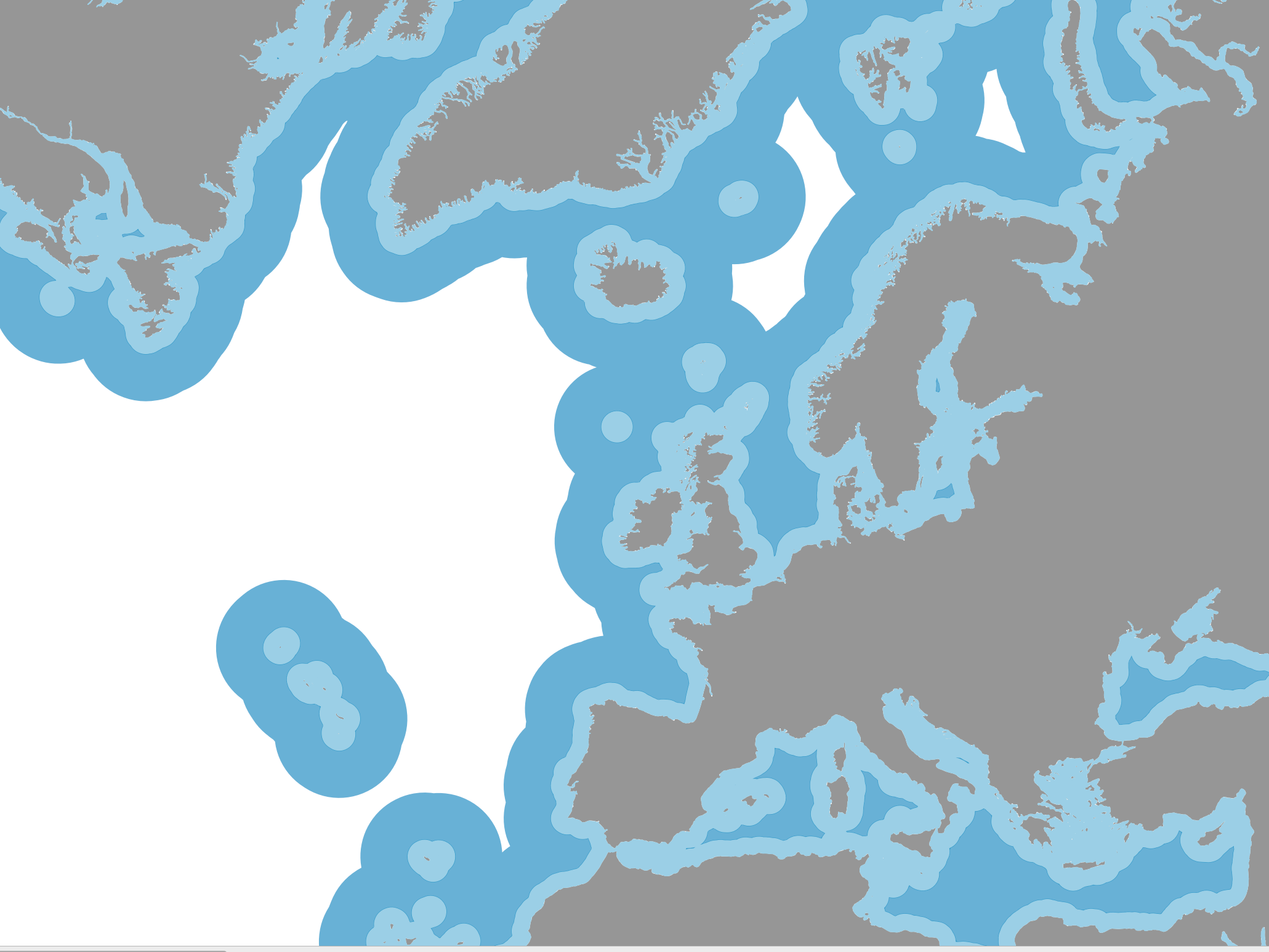
I made this map in response to a comment on a recent post about sailing insurance. That post mentioned the 50-nautical-mile and 200-nautical-mile limits that appear again and again in insurance policies. Samuel wondered what those restrictions would actually look like on a map.
This is what they look like in Europe.
From Distances to Risks
The map shows Europe with two distance bands measured from shore: 50 nautical miles in light blue and 200 nautical miles in darker blue. Land is shown in gray. White represents waters beyond the 200-mile threshold.
Nothing else.
No routes. No weather. No arrows.
Just distance.
To make sense of insurance restrictions, it helps to translate distance into time. At a conservative average of 100 nautical miles per day—a reasonable planning number for a modern cruising sailboat—50 miles corresponds to about half a day from shore. A long day sail. Somewhere you could leave in the morning and still reasonably expect to return before nightfall.
Two hundred miles is roughly two days. A short offshore passage. One night at sea, maybe two if things go poorly.
Rescaling nautical miles into time turns an abstract geographic threshold into a lived experience. What looks like an arbitrary line on a policy suddenly maps onto fatigue, darkness, uncertainty, and exposure.
Light blue is a day sail.
Dark blue flirts with offshore sailing.
White is where things start to get serious.
Europe, Seen Through Distance
Start with the Mediterranean. It is almost shocking how contained it is. You can cross vast stretches of the Med without ever getting more than 50 miles from land. Even when you feel offshore, you are never far from a coast, a port, or a country.
Looking at this map, it is easy to imagine the journeys of Ulysses, or the trade routes sailed by Phoenician, Greek, and Roman ships. Mare Nostrum—our sea—because it is so confined, so landlocked.
Shift north to the British Isles and Northern Europe, and the pattern largely holds. Most sailing grounds remain within 50 miles of shore. And with a slightly greater appetite for risk, almost all of Europe can be traversed without ever exceeding 200 miles from land.
Seen through this lens, the Vikings' routes begin to make intuitive sense. From Scandinavia eastward toward the Baltic and Russia, or westward toward the British Isles and France, they could travel while staying close to land. Later, pushing farther offshore, they crossed from Scotland to Iceland, then from Iceland to southern Greenland—still largely within the 200-mile envelope. Only with the final leap from Greenland to Newfoundland did they truly move beyond it.
One striking feature of Europe is how distance from shore shrinks because of small, strategically placed islands. The Faroes are a good example. Few people could point to them on a map, yet for sailors heading from the UK to Iceland they represent a critical refuge. Geography quietly shapes what feels possible.
Even many high-latitude destinations—Greenland, Iceland, Svalbard—remain surprisingly close to shore in purely geometric terms.
Beyond Distance
And yet, as soon as we start talking about Arctic waters, the limits of this metric become obvious.
Distance from shore only matters if the shore provides protection.
Some do not. Jan Mayen, a small volcanic island north of Iceland, offers no real refuge at all. In that case, proximity to land increases risk rather than reducing it. The same is true along parts of Iceland’s south coast, where heavy surf, few harbors, and poor holding make landfall more dangerous than staying offshore.
Near ice-covered coasts, being “close to shore” may instead mean exposure to sea ice, icebergs, or uncharted reefs. In these contexts, the meaningful measure of safety is not distance to land, but distance between refuges.
Insurance underwriters know this. Distance bands are rarely the whole story. They are often paired with latitude–longitude boxes, seasonal exclusions, and named regions that encode accumulated experience about weather, ice, and rescue capability.
Still, distance is where the conversation usually starts.
Geek’s Corner: How the Map Was Made
For those curious about the mechanics: the map was built using open geospatial data and standard GIS tools. I started with the Natural Earth land polygon dataset, which represents coastlines as land areas rather than navigation routes. All processing was done in QGIS.
To compute distances accurately, the data were reprojected into a metric, equal-area coordinate system (ETRS89 / LAEA Europe, EPSG:3035), so distances are measured in meters rather than degrees. From the land polygons, I generated uniform buffers at 50 and 200 nautical miles, corresponding to common offshore insurance thresholds, then removed the land itself to retain only the offshore zones.
The result is a purely geometric view of Europe—distance from shore, stripped of politics, routes, and chart conventions.